Secret places in Google Earth - the top 10
Related Videos: 10 Secret Places Censored on Google Earth (May 2024).
Google Earth is a hugely popular service - you can see satellite images from virtually anywhere in the world for free. But there are exceptions: We show 10 secret places that have been made unrecognizable on the Google map and are therefore kept from the user.
10th place: French nuclear power plant in Marcoule
- Marcoule in southern France is home to a nuclear power center. Large parts of the area are said to remain hidden from the outside world.

9th place: Ministry of Defense of the Netherlands
- The city in the heart of the Netherlands is home to several military facilities such as barracks and military training areas. In addition, parts of the national ministry of defense are housed there.
- The consequence, however, is that parts of the satellite images have been provided with a colorful mosaic pattern. Apparently, the user should not have direct insight into the state institutions.
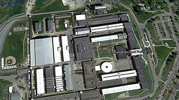
Rank 8: New York State High Security Prison
- In the United States, most prisons are subsequently alienated on Google Earth images. At the Elmira Correctional Facility, too, several parts of the building were whitened to make details unrecognizable.
7th place: NATO base Geilenkirchen
- Even Germany is by no means free from mysterious places: the military airport Geilenkirchen, right on the Dutch border, is only partially visible in Google's satellite images.

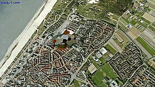
6th place: Dutch Royal Palace?
- Once again we go to the Netherlands, this time to the coastal city of Noordwijk. Parts of a settlement are completely blurred here. The Dutch royal family is said to own a house there.
- However, the paradox of this Google censorship is that the pixelated area in Street View is freely accessible. Instead of taking a bird's eye view, you can simply stroll virtually through the streets.
5th place: NATO base at Reims Airport
- The French military airport in Reims has not been used since 2012, but apparently still has something to hide.
- Most of the airport, which was also used as a NATO base, is openly visible. Only a small piece of forest north of the runway is pixelated by Google. What is hiding here?

Rank 4: tourist castle in Barcelona
- The Montjuïc in Barcelona is a popular destination for tourists. There is even a castle on the hill from which the military used to rule the city. Today everyone can actually see the building - only in Google Earth it was censored afterwards.

3rd place: Logistic center of the Taiwanese military
- The logistics center of the Taiwanese army is said to be on the outskirts of the metropolis of Taipei. This is not so easy to check on Google Earth - the area is covered by large shadows and a complete building complex has been pixelated.
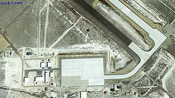
2nd place: US military base subsequently altered
- The American Army tests chemical and biological weapons on the “Dugway Proving Ground”. Therefore, several buildings of the airport in the state of Utah were whitewashed.
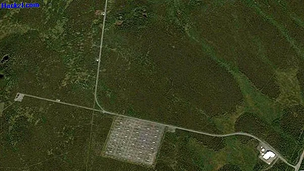
1st place: HAARP - US research center in the middle of Alaska
- HAARP is the gallant abbreviation for "High Frequency Active Auroral Research Program", an American research project in the middle of the Alaska forest. The earth's atmosphere is to be examined here with radio waves.
- Google Earth users hardly get any clarity about the site and the processes there. Parts of the area have been blurred. After all, with Street View you can catch a quick look over the fence of the screened area from the adjacent main road.