
Google Earth: measure distances - how it works
You can use Google Earth to measure the distance between two or more points, for example to determine the length of a route. In this guide you will read how to use this practical function.
Measure distances with Google Earth
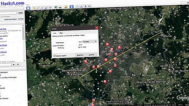
To be able to measure a distance in Google Earth, the software provides you with a ruler tool. You can do this by clicking "Tools" in the menu bar and then "Ruler". You can then measure either a line or a path.
- Line: Use this option to measure the distance between two points on the ground. As soon as you have marked the starting point with the left mouse button on the map, you can read the current map length, length on the ground and the direction to your mouse pointer in the "Ruler" window. With another click you define an end point.
- Path: This function is intended to measure the distance between several points on the ground. With the left mouse button you can set any number of points on the map, in the "Ruler" window you can see the length of the current route.
- Incidentally, you can change the unit of measurement of the displayed route at any time and thus switch between meters, kilometers or miles.
How the area calculation works with Google Earth, you can read in the next practical tip.